
DCS Mission Editor: SAM Map Appreciation
- Aaron "Ribbon-Blue" Mendoza

- Sep 6, 2025
- 5 min read
Hoping a Simple Addition Becomes a Consistent Trend

One of the hardest parts about mission editing in Digital Combat Simulator World (DCS) is knowing where to start. Even the free Caucasus and Marianas maps are highly detailed with hundreds of miles of fields, oceans, buildings, railways... all without much of a way to find them easily. At most the map layer in F10 may have a few hints at useful locations if you know what you are looking for.
Which map? Where to start? Are there unmarked military facilities in the grid square you randomly chose, or will you commit to the arduous task of building custom villages, revetments and bases from scratch? Are you willing to do some research of the countries and regions of each map to find what you are looking for?
There were some maps in DCS that offer fast references important for easier mission building. Not enough to effortlessly create missions like 107th Joint Aviation Squadron's Through The Inferno multiplayer servers or Reflected Simulations single player campaigns, but a solid building block towards greatness. In a simulator focused on combat aviation, nothing is more important than air defenses.

TRADITIONAL METHOD
Here is an anecdote on this subject from my time mission editing.
One of my tried-and-true methods in creating new missions is scrolling through maps grid by grid. Zooming in and out constantly to see individual buildings, fields, vehicles etc. Cycling through the different map layers to see all details. Any notable areas or objects I see are then added to a text file, spreadsheet or some other type of document for later reference.
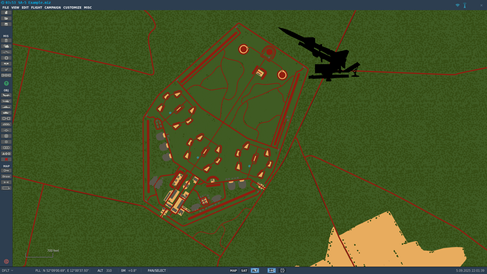
While planning a scenario in the Syria Map by Ugra-Media, I found an important historical part of the country's military history. Deep in the open terrain of the southern half of Syria, near the borders of Jordan, Iraq, Israel and Lebanon I found a pair of circles made up of smaller circles. In no way was this a natural landform.

Reviewing the F10 map also yielded no information. This mystery structure had all the markings of a traditional Surface to Air Missile (SAM) Site. Specifically in the SA-2 Guideline configuration, but by standard doctrine, it had too many TELs or "missile rails".
Mouse dragging my way through grid squares of surrounding desert, similar circles were revealed. Each of them strategically placed across the southern part of the country. Upon finding a second double ringed complex with no references on map, I took to the internet for days to research. Eventually I found declassified documents from the American Central Intelligence Agency Freedom of Information Act Electronic Reading Room. In particular the "SA-5 SAM Complex Construction" and "SA-5 Complexes and Associated Facilities in Syria" were very illuminating. More research and declassified documents later, I had an entire portion of the Syrian Integrated Air Defense System (IADS) reasonably modeled within the simulator.


Samples of information from declassified documents.
Now of course DCS World itself is not 1 to 1 real world accurate in many aspects, exact GPS coordinates on maps being one of them. However, all of this got me close enough to model things out as needed. Now for this part of the Syria map I have a go-to set of large-scale air defenses to increase or decrease, augment with other air defenses or use as a backdrop for smaller missions that can occur in that area. It is a starting point any mission in a combat flight simulator could use.
THE NEW WAY
Fortunately, DCS: Sinai Map by OnReTech and DCS: Cold War Germany Map by Ugra Media are providing a new, simple in-game feature that streamlines this process.
As much as I could go on about the unbelievable amount of human level detail in the Cold War Germany map, players are definitely more interested in the more combat oriented aspects of the map. Understandably so. The Fulda Gap isn't going to fill itself after all. Though, the baseline of every potential mission on the map could include the larger parts of the Integrated Air Defense networks in both North Atlantic Treaty Organization controlled West Germany and Warsaw Pact controlled East Germany. If even a quarter of it was modeled in a mission, it would be a significant backdrop to all air operations.
Important military facilities, such as SAM sites and early warning radar locations, are marked on the maps with easy-to-understand icons. Missile Icons for SAM sites and Radar Icons for radar stations. In the mission editor these icons occupy the Geo Names layer, where the names of cities and towns are displayed.

Without doing any research, these sites can be populated with mission appropriate air defenses at the discretion of the editor. Feel free to switch out those old MIM-23 HAWK batteries for new IRIS-T launchers if your modern scenario calls for it.
Though, with a bit of entry level research (e.g. search terms like "West Germany HAWK Sites", "East Germany cold war early warning radars", etc.) these positions can eventually be populated with era appropriate units. My favorite example of this being the keystones of the Warsaw Pact SAM Belt: the SA-5 Gammon bases.


Mission editors will need to manually place units into the correct positions for each location, but this is a welcome change from the traditional method. Once the medium and long-range air defenses are in place - as many or few as the editor chooses to include - missions can be created beneath their air defense umbrella with editors knowing they can focus up on the finer details of their primary objectives.
Map icons, and by extension air bases and heliports at notable locations, are something that I hope other third-party companies that create terrain include in future and current maps available in this simulator.
SALUTING USER FILES
Digital Combat Simulator has been around for over a decade now in one form or another, so it should come as no surprise that devoted users that go above and beyond to enhance their preferred flight sim have tackled this subject before.
The User Files section of the official website for DCS world is mainly compromised of liveries and downloadable missions, but unit and location templates can also be found. In fact, in the File Type dropdown menu there is a Static Template sub-category. Further templates outside of that category can also be found with the search bar using terms like "Persian Gulf Template".
These templates are jam packed with units - both static and active units. They are placed in known real world locations or contain pre-made areas to fill out parts of maps. While running these templates as is could be problematic as they are quite heavy. Mission editors are encouraged to save a copy of the template as a new mission. Afterwards they should trim out parts of the template they do not want to keep, then add their desired units for the scenario they have in mind for the sake of maintaining in-game performance for players.
I send my regards to the dedicated experts that build these templates in the 'traditional way'. As shown in my personal example, it takes hours or days of research.


About the Writer

Co-founder of Skyward Flight Media. After founding Electrosphere.info, the first English Ace Combat database, he has been involved in creating flight game-related websites, communities, and events since 2005. He explores past and present flight games and simulators with his extensive collection of game consoles and computers. [Read Staff Profile]


